Pohnpei Part I

As much as Saipan was an exciting adventure for me, it was really just a dry run for the ultimate goal of my brief but memorable island-hopping campaign: the mysterious island of Pohnpei. First, of course, some background. The reason you’ve never heard of the place is because it is a tiny spot in the western Pacific, northeast of Papua New Guinea and on the other side of the equator. It is part of the Caroline Islands formation and Pohnpei is the capital island of the Federated States of Micronesia. It differs from Guam and Saipan in some important aspects. First off, we (‘Merica) don’t own the place. It is an independant country, and although the US is a close associate, this was travel to a foreign country for me. Second, the people on Pohnpei and in the Caroline Islands are Micronesian instead of Chamorro. The most significant thing about Pohnpei, for me anyways, is that it is the home of the ancient ruins of Nan Madol.

I first heard of Nan Madol when I saw a documentary on the ruins, I think. When I came to Guam I was surfing Atlas Obscura when I found out that the ruins were just a short hop away from me. Nominally, anyways. I filed it away as a place I really ought to go and then spent the next three years dilly-dallying about it. I took one shot at it but travelling to Pohnpei was slightly more than trivial for me when I was on the submarine and it fell through. In limbo up at squadron, however, I spotted my chance and decided to take it. I actually went AWOL to take this trip, playing hooky from work on a Friday and travelling internationally without permission to make it happen. The upswing of all that is I only had a weekend on the island, which is far too short, and the only person I told about visiting the island until I was out of the Navy (like I am by the time this is posted) was my grandma.

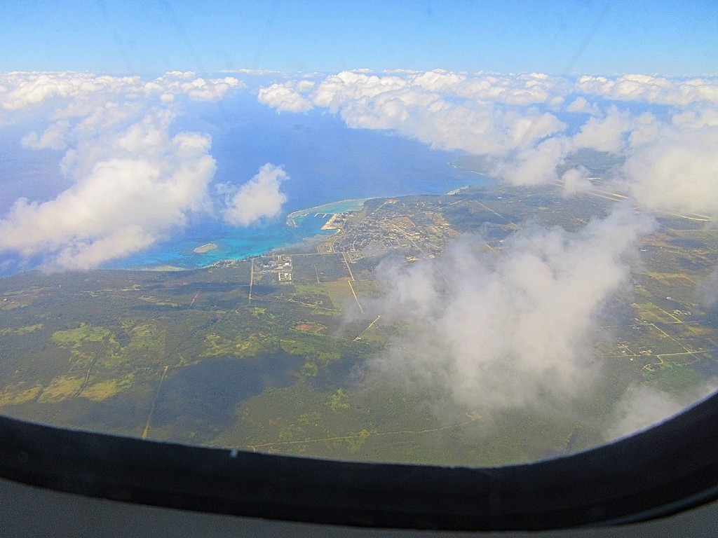
I departed for the island early on a Friday morning. United is the only airline that regularly flies to the island in a short island-hopping route from Guam, to Chuuk (sometimes spelled Truk), Pohnpei, and back from whence it came. This plane only comes around three times a week, which gives you a indication of the interest in travelling to the FSM. The flight over, including the Chuuk stopover, is about three hours and is gorgeous. The Carolines are spotted all over with stunning coral atolls that look like they’d be treacherous to navigate by sea but are beautful from the air. Landing on the islands is other-worldly. Kudos to the pilots, because the runways on both Chuuk and Pohnpei are terminated on both ends by water and you could tell it took skill to set that plane down safely. The islands themselves are incredibly lush and I was glued to my window during the whole approach. Pohnpei is one of the rainest spots you’ll find and gets somewhere north of 25 feet of rain a year. Seattle gets something like 38 inches. The rain means central Pohnpei is usually surrounded by mist, with a cloud forest in the highlands of the island, and the rest covered with dense tropical rainforest. I considered Saipan to be a bit run-down, but my impression of Pohnpei is severly underdeveloped. You can’t even consider the largest city in Micronesia to be a one stop-light town; iPhones have reached the FSM, but stoplight technology has not. The lack of development (which is a good thing) and the jungle make Pohnpei look like an island lost in time and I wouldn’t have been all that surprised to see a dinosaur emerge from the edge of the runway, Isla Sorna-style.

After picking up my bag and surviving the toughest grilling I’ve ever gotten from a customs agent, I picked up my rental car (a Yaris this time) and headed to my hotel, the Cliff Rainbow. Driving in Pohnpei is a bit of an adventure. Like I said, there are no stoplights, which I am very much alright with, and also not much in the way of traffic laws in general, which I am also very much alright with. I think I saw one speed limit sign my whole time there, but everyone is kept travelling at a relatively safe pace by the sheer number of dogs, chickens, and small children occupying the street at any given time. I managed to go my entire weekend without hitting anybody or anything, but that was only by learning the ground rules: dogs have the right of way, and are none too eager to move. I got to my hotel in short order, checked in, and headed back out the door.

Driving on a main road.

Saipan Part V

Time to wrap this story up with the embarrassing parts, but first I’ll mention Wild Bill’s. Wild Bill’s 2 is on Guam and is a pretty decent little bar. They will serve you alcohol and also bar food. Wild Bill’s 2 is the second one because the first one is on Saipan and is called Wild Bill’s. Wild Bill’s is a Thai restaurant that will also serve you beer. The success of my bar hopping attempts should have been an indicator for the rest of the night.

Having struck out, like I mentioned a while ago, with my Shanghai connection (but not after a conversation that included the un-memorable line “You’re not into cuddling, are you?”), I decided to sample the night life on Saipan. The only obvious strip club I spotted on Saipan was a place called “King’s Club.” I thought this place was terribly quaint. When I first walked in at nine, an hour I usually consider perfectly reasonable but is apparently way too early for the rest of the world (kids these days), I was the only guy in there and I thought they were closed. I took my seat and soon after a sizable mass of Chinese tourists walked in and the show began. Eventually things went as they usually do in strip clubs and I started talking to Angie. Angie was from Mongolia. When she first started talking to me she thought I was Russian. I think this whole experience is demonstrative of the effects of globalization and the efficacy of racial profiling. To give you a sense of the Saipan economy, stripper drinks cost $25 and the VIP area was $100. She related to me that her friend had gotten a visa to Guam where the opportunities were reported to be fantastical. I confirmed for her that the strippers were better paid. I eventually left when the place closed at four in the morning somewhat poorer, but, you know, when in Saipan.

The next morning, or more accurately mere hours later, I woke up with the obligatory headache, as much from my sunburn as the meager amount of booze. I am getting old. I took a shower and gathered my things and went out to face the day. I went for breakfast at a cafe by the park called Cafe by the Park. It featured a cute waitress in high-wasted jeans. I got the fried rice. I regret not getting the banana crepe. I paid with the remainder of my stripper $1s. For entertainment that morning I checked out the American Memorial Park, across the street from the Cafe it lent its name to. It is a very nice little park with a high-quality museum and was apparently recently hit by a typhoon. The Carolinian thatched hut was not there, presumably showing the one weakness of thatched-hut living vis-à-vis typhoons. I bought a lapel pin at the gift shop and checked out a Japanese pillbox until it was time to head to the airport.

Note the tanks.

Places like Saipan amaze me. Who has even ever heard of the place? To answer my own question, apparently tons of Asian and Russian tourists. The amount of tourist traffic to the Marianas kind of blows my mind. On one hand, I enjoyed the island entirely. The island is smaller than Guam but didn’t feel small while I was visiting. Saipan has a great deal of natural beauty, the upswing of being underdeveloped. The abruptness of how the cliffs of Saipan meet the ocean gave you a sense of power that Guam doesn’t quite have for me. On the other hand, it’s a tiny out of the way spot where the airport has all of two airline counters but somehow manages to garner enough tourist traffic to warrant a luxury brands shopping mall. Just to shoehorn in this reference, by the way, the mascot of Saipan is a panda with a weird nose. It is called the “Saipan-da.” I didn’t get it at first, but when I did I was all like “ha, okay.” I’m on the side of the Asian tourists here though. I liked Saipan. It is out of the way and has that somewhat run-down tropical feel that I love. If you ever have a weekend free and find yourself in the Marianas give it a go.

Bye Saipan

Saipan Part IV

I apologize again that I’m the sort of person that thinks it is okay for me to milk one weekend in Saipan out into what looks like it’s going to be five parts. Thanks for sticking with me. Just think, with writing this good, you don’t even have any need to go to Saipan yourself. It’s like you lived it. To save myself some space, and to skip over some more forgettable parts of this trip, I’ll volunteer the following: I went to Tank Beach where the only really memorable thing was a giant penis made out of rocks, and, despite my best efforts, I was unable to find the purported but I’m convinced mythological botanical gardens of Saipan. Exciting stuff.

The internet had told me that the drive up to Mt. Tapochau would be treacherous and that I should have a good car. The place wasn’t hard to find at all due to some conveniently placed spray-painted signs. I figured I would keep going until the road was too bad, but I got all the way to the top and had the place to myself for a while. The wind was very strong the day I went up there and I had to hold onto my hat lest I lose it in all it’s stupid-looking glory. The views up there are pretty magnificent. Although it reveals the depth of the research I did before going to the island, I didn’t realize that Tinian was so close to Saipan until I got to the top of the mountain. Up on the mountain there is an obligatory shrine and some signs talking about the American invasion of Saipan. The most notable thing I learned is that the Japanese were aware that if they lost Saipan, it would open the floodgates to American attacks on the Japanese mainland. The Japanese were told to fight to the last man. We all know how the story ended, but that gives the reasoning behind the fierce suicide attacks staged by the Japanese. To bring us back to the mountain, however, you can see the whole south end of the island and see as the island stretches into the north. There were plenty of houses up towards the top of the mountain, and although I don’t imagine that any of the cars I usually drive would make it on a daily basis, it must be a really nice view out their window every day.

My driving tour of Saipan complete, I decided it was time to hike down to Forbidden Island. This is one of the classically picturesque spots on Saipan, featured in the influential “Islands of the Marianas” calendar, available at an ABC store near you. The island is forbidden because it is supposedly haunted. After the hike, I think this was a clever trick by Chamorro moms not wanting their kids to break their necks on any sharp cliffs leading down to the place. But except for some steep rocky bits the hike isn’t too bad, and offers very nice and increasingly close views of the island itself. I suppose I didn’t do the math before the hike, but I got over to the beach and was somewhat surprised that I couldn’t manage to get over to the island itself. You know, because of the water that makes the thing an island. It looked closer from farther away. The beach was a nice place to wander around and I quickly discovered a Chinese couple. They were snorkeling. The man saw me taking pictures of the place and offered to take one of me. I had worn my stupid-looking hat for this hike, but since it looked stupid I took it off and struck decided to strike a pose for some reason that was somewhere on the low side between “Napoleonic” and “somewhat dazed.” My newly selected photographer, for his part, crouched to get a good angle I guess and decided to frame the picture not with Forbidden Island in the background, but another random large rock. I’m not one to criticize other’s artistic choices, but between the two of us Ansel Adams we ain’t. It was nice to get a picture that wasn’t a poorly shot selfie though.

Wandering the rest of Forbidden Island Beach, I looked at tide pools and watched as the waves crashed over some rocks a little offshore. I also spent more time marveling at the geology of the island, with the entire cliff-face looking like it was cast out of concrete. The water was incredibly blue and there were many colorful fish swimming about. “Very beautiful,” in the words of my beachside artistic accomplice from before. Eventually I steeled myself for the hike back up the cliff and walked away from the experience with a sunburn. Wiped out from a now rather full day of Saipan sightseeing, I headed back to the hotel and took a shower before dinner.

Saipan Part III

The view from Suicide Cliff

Not to half-ass my journey through Saipan locations famous for mass suicide, I next drove up to Suicide Cliff. The background information is the same for Suicide Cliff or Banzai Cliff, except like I said in Saipan Part II (this is getting long for one weekend to Saipan, I know, I’m sorry), Suicide Cliff is inland and below it is a thin strip of jungle and Last Command Post Park. Reaching Suicide Cliff just requires an easy drive up the back side of the mountain, and there is a small park with a parking lot and several small shrines and memorials. Walking up to the cliff, the views are fairly spectacular. At Banzai Cliff you could feel the power of the ocean, but at Suicide Cliff you can look out over it for miles. The land between Suicide Cliff and Banzai Cliff used to house a very large airfield, but is now mostly jungle, interrupted by a Veteran Cemetery with no dead people and a landfill. Despite the landfill, the view is well worth the short drive.

Although it’s not my usual habit, shortly after landing in Saipan I had fired up Tindr. By this point I had started chatting with one woman who was on Saipan out of Shanghai on a company trip. To avoid any cliffhangers, we didn’t see each other, but she did mention that the Grotto was “so amazing.” She mentioned this about three times. She related how Saipan was pretty boring for her, except for the Grotto, which, like I mentioned, was “so amazing.” I’m not a diver, so I didn’t dive the Grotto, but I did stop by to see if I could find out what all the fuss was about. The Grotto itself is a pool that is protected by a rock overhang and connected to the ocean via an underwater passage. I drove to the site and walked down a set of fairly steep steps. It was nice to see, with some colorful rocks and some weird tadpole-looking things and water rushing in and out with the waves. Upon further pressing, my Shanghai connection said there was a shark and some coral stuff underwater, if that wets your tastebuds. Above the waterline, however, the Grotto’s Entertainment value was spent and I headed out.

To round out my tour of northern Saipan, next up was Bird Island Overlook. I’ve waxed and waned about the cliffs of Saipan, and of Bird Island I can say the cliffs continue with earnest. Bird Island itself looks like a broken-off edge of a crater, and it provides a nice focal point for more gorgeous views of the Pacific Ocean. I did see some birds, but no more than were to be seen on the rest of Saipan.

Prior to leaving Guam I had gone to the ABC store to buy a hat. It was a stupid hat. I did not set out to buy a stupid hat, and normally I have an array of adventure-appropriate hats, but these were packed away and I needed a hat to keep the sun off my head and the ABC store isn’t known as an ample purveyor of fine hats. So I bought a stupid hat. I ripped off the stupid-looking hat band to make it a slightly less stupid looking hat, even though that left a bead of hot glue around the crown. All of that to say, at the Bird Island Overlook I spotted an opportunity to wear my stupid hat in the form of a sign saying “Kalbera Cave.” At the time I didn’t know what it was. Further internet research has revealed it’s a largish cave where the natives at one point possibly hid from the Japanese and subsequently American invasions, but on that Saturday I was forging into unknown territory. The direction which the sign alluded to was down a dirt road, and since I didn’t know the condition of the road or the exact contents of my SUV rental agreement, I decided to take off on foot towards Kalbera Cave. My morale on this hike quickly degraded, however, with every pickup truck that slowed down next to me to ask if I was alright. The journey was pleasant enough I suppose, with me gawking at cliffs and avoiding carabao dung, but with more and more road and no Kalbera Cave to be found, I turned around and decided to just drive to Kalbera Cave. I made it back to my SUV, but my Kalbera dreams were thwarted by the site being an active construction zone. It looks like it might be a really nice attraction someday, but today was not that day.

Thirsting for excitement nonetheless, I forged on past Kalbera Cave, over increasingly deteriorating road. This is where I was glad to have an SUV, cresting over hilltops, forging across streams, bouldering in some nice air conditioning, thinking that maybe I should have read that rental agreement after all. Eventually, despite getting lost only once, I made it back to a paved road. I could have, of course, just stayed on paved road the whole time and had the same effect, but I’m not one to take the logical, sensible way out.