

Reading this week:
- Future Boy by Michael J. Fox and Nelle Fortenberry
Like I warned last week, oops, I have become a train guy. I mean not quite but almost. I complained a few weeks ago about how the history of Sierra Leone wasn’t so obvious to me like it had become in northern Zambia, but things are clicking into place. To the point where, as of writing this (early 2024), I am worried about drifting away from my dream of writing a book about the Central Africa Mission of the London Missionary Society (which I am totally going to do, as soon as I 1) spend weeks in the archives in London, 2) gain journalistic training and travel to Mbala for weeks to gather reflections on the current impact of the mission, and 3) achieve a sort of self-starting discipline I can’t even keep up to keep this blog updated). But things are clicking into place. As I’m starting to find some of the colonial history of Sierra Leone that shape the physical and societal patterns of the place you can spot the remnants of history. Like Hill Station.
So we have been living here (again as of writing) in Hill Station the neighborhood. It was upon visit to the train museum and reading the little pamphlet we bought in the gift shop that I realized that comes from like, Hill Train Station (a little more research later I’m unclear if that is true, this Hill Station was patterned off a Hill Station in India so the technical etymology of the name might not be a literal train station). Since I like looking at the remnants of history, I wanted to figure out where the actual Hill Station was. I spent a little bit of time looking around on Google Maps satellite view for anything that looked like an old train station or a train right-of-way, but I pretty quickly deemed that as unlikely to yield results. Luckily though I thought of looking at old maps and hit the jackpot right away.
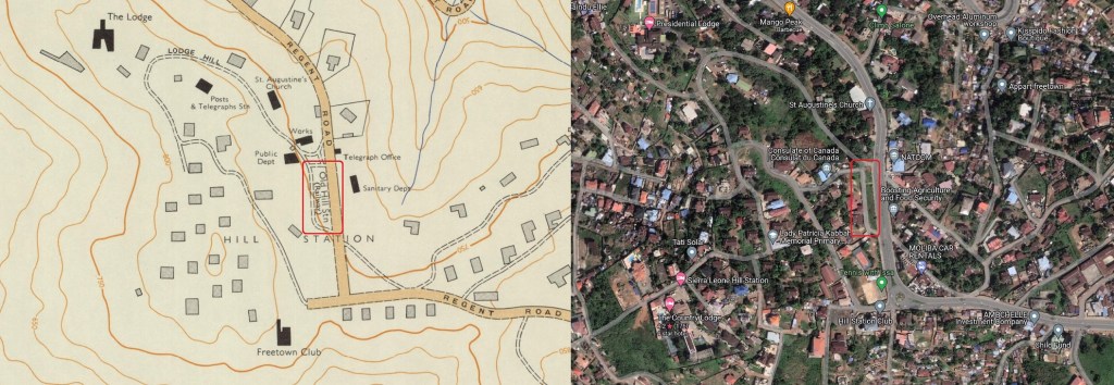
In the top right corner of this map, if you zoom in, you can see a little traffic island sorta thing labelled “Old Hill Stn (Railway).” Well that solved that mystery. It also pointed out where “Hill Station” (the neighborhood) actually was. When I was zooming around Google Maps I was looking too far up the hill. Another thing looking at the old maps is that it is remarkable (to me, I am remarking on it) how much more developed the area is than it was at the tail end of colonialism. These hills are now covered in neighborhoods and houses whereas before Hill Station was an isolated little enclave in a sea of forest.
Speaking of which, what was Hill Station, the neighborhood? Like I just said, an isolated little enclave. Around the turn of the century the British administrators decided that living up on a hill would be a lot better idea than living down in Freetown where their offices were. This was ostensibly for health reasons, to get up into the breezes which hopefully would mean there were far fewer mosquitoes. However, as explained in this excerpt from The Creoles of Sierra Leone by Leo Spitzer, in implementation it was a bit more racist than that. Not only would the neighborhood be mosquito-free, but it would also be largely free of anyone non-white, except for the adult servants of the white administrators living there. They put signs up a mile out to keep anyone from even planting a garden. Leo Spitzer’s book is about how Sierra Leonean society split from the British colonialists, and Spitzer credits this spatial separation of administrator and administrated for part of that.
Anyway the other thing about Hill Station is the old houses. Sierra Leone is known for old houses but these old houses are different. The Hill Station neighborhood was not only racist but also expensive. To get all the way up to the hill they had to build a whole railroad, hence the creation of the Station of Hill Station. The neighborhood and railway were built roundabout 1902-1904. The houses they built were referred to as “Harrods Houses,” because they were ordered from Harrods (as in the department store), shipped to Sierra Leone, and constructed on the spot from the kits. So scattered around the hill are apparently 12 of the original 24 or so Harrods Houses with their distinctive look. Not too bad for some pre-World War I kit houses (here is a site with some interior shots).
Circling back to trains, once I figured out where the Hill Station Railway station was, I wanted to figure out where the old railway line was. There was not conveniently wonderful old maps of the railway line that I could find easily. The line only ran until 1929 when there was a nice enough road and enough of the administrators had cars to make it no longer necessary. So any maps I found would have had to be made in that era. One map I did find (via this blog) was on this wonderful website all about post offices that existed on trains and ships, which is a wonderfully niche hobby that I am in real danger of falling into the very moment I turn 40 (check out their committee page). It is not a very exact map but I started to try to trace the route which led me to discover the road with the extremely convenient name Old Railway Line so there’s another mystery in the bag.
But the whole point of this blog post is that after all this research on the Hill Station railway line and hill station itself I went over there and checked it out. It was a lovely little walk on a Sunday morning (to try to make sure it was relatively quiet). First I went to the spot of the old railway line hoping to find some evidence of its existence, but alas not really:

Then I walked up the hill to check out the Harrods Houses. I had spotted them before on the way to the Country Lodge Hotel and thought to myself they had looked colonial, so I was pleased in the course of all this research to discover they really were. They are popular houses to photograph (and, for the artist Frédéric Lère who I found via Google Maps of all things, to paint) though I tried to be a little discreet.

So the point is, history is cool, trains are cool, and going on walks is cool.

You must be logged in to post a comment.